News and Media
Terrestrial Laser Scanning

Carbon stored in forests is a key part of the global carbon cycle. Improving our knowledge of how carbon is stored and how its changing is vital to enable us to value, manage and protect forests effectively.

New observations from ground-based laser scanning are helping to address this uncertainty by providing a ‘gold standard’ against which we can benchmark satellites, aircraft and UAVs.
Trees and forests are a key part of the terrestrial ecosystem, providing food, shelter, biodiversity and of course locking up vast amounts of carbon as a by-product of photosynthesis. Yet we know that globally, forests are facing multiple threats: deforestation and degradation (both legal and illegal) for timber and clearance of agricultural land, more frequent and severe droughts, increased risk of fire, more and more rapid spread of pathogens etc.
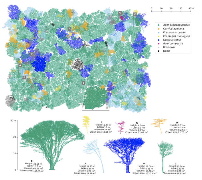
A number of new and forthcoming satellite missions are aimed at estimating forest carbon, for example the European Space Agency BIOMASS mission. Satellite observations of forest carbon rely on ground-based measurements of forests to underpin their accuracy. NCEO researchers have developed new ground-based techniques to assess forest carbon in more accurate ways using terrestrial laser scanning (TLS). This technique captures trees in highly accurate 3D detail, enabling them to be ‘weighed’ very accurately, as well as providing a host of other useful ecological detail (see figure 1).
Recent NCEO-led work on UK woodlands using TLS has shown that there is up to 80% more carbon stored in typical UK forests than previously thought, a consequence of limitations of previous models. There is a need for these type of measurements across forests globally to help improve our use of satellite and aircraft observations of forest carbon. NCEO researchers are taking a leading role in these activities, for example as part of the GEO-TREES initiative (https://geo-trees.org).

Across NCEO we specialise in developing these new technologies to provide new measurements and models. A vital part of this is collaborating with plot-based field measurement networks that have been making long-term manual measurements of forest plots (e.g. forestplots.net).
Tools
New TLS tools have been developed in conjunction with NCEO researchers at UCL and PML. Algorithms for the NASA GEDI mission and the forthcoming ESA BIOMASS missions use data collected by NCEO researchers, as well as other model results. These new TLS tools and approaches are part of the IPCC Greenhouse Gas inventory best practice, as well as part of the Committee on Earth Observation Science (CEOS) protocol for calibration and validation of satellite biomass.
Contact
For further information contact Prof Mat Disney at UCL or Wanxin Yang, NCEO PhD Student.
Latest News and Events


